Sports
Heat builds across Alberta, with ‘ring of fire’ setup bringing severe storm risk

Some of the heat currently scorching B.C. will seep into Alberta this week, along with a humid air mass, which will eventually set the stage for severe thunderstorms on Wednesday.
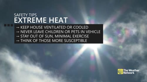
Heat warnings cover much of Alberta, with Environment and Climate Change Canada advising folks to take precautions to protect themselves, their families and their neighbours.
DON’T MISS: Will Death Valley flirt with a world record next week? It’s on the table
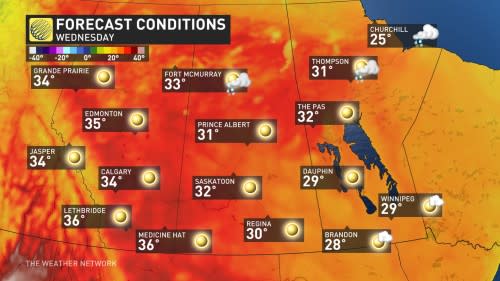
Temperatures will be on the hot side Tuesday, soaring to as much as 13 degrees above normal in parts of the province. Widespread, 30-degree daytime highs will be prevalent, with the southern areas being on the higher end of the values. That’s after several communities broke new daytime high temperature records to start the week on Monday.

With the muggy air mass that will push humidex values well into the 30s, the hot weather will be a fuel for a severe thunderstorm threat come Wednesday and Thursday.
It’s part of a “ring of fire” set up, which is a meteorological term that refers to the path that storms take around the outer periphery of a high pressure centre or heat dome. Because of the excessive heat generated and radiated by the heat dome, storms along its boundary can be quite severe, as they tap into the extreme heat.
Strong winds and very large hail will be the main threats with storms that develop this week.
Tuesday: Heat turns up in Alberta, precedes storm threat on Wednesday
Temperatures will be 10-13°C above normal across most of the province of Alberta on Tuesday.
Dew points will approach the upper teens across central Alberta on Tuesday, making the air mass uncharacteristically muggy as humidex values tip into the upper 30s.
There is high confidence that peak the heat arrives across the province on Tuesday and Wednesday, ahead a cold front that is in question for Thursday.
The potential for thunderstorms pops up across Alberta on Wednesday as an upper-level impulse moves in aloft, acting as a storm trigger.
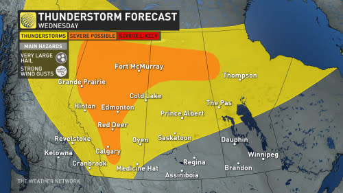
Because of this ‘ring of fire’ set up, we’re watching the risk of hail possibly exceeding 4 cm in diameter this week across the Prairies, with a robust amount of available storm energy.
By Thursday, that trough will push towards the Saskatchewan border and bring the storm risk eastward as it moves.
The Canadian Red Cross also recommends taking frequent breaks while working outside, wearing a hat while outdoors, and avoiding drinking caffeine and alcohol as they can cause dehydration.
-
Consider rescheduling outdoor activities to cooler hours of the day.
-
Spend time in cooled indoor spaces where possible.
-
Check for your children or pets before you exit your vehicle. Do not leave any person or pet inside a closed vehicle, for any length of time.
Monitor for symptoms of heat stroke or heat exhaustion, such as high body temperature, lack of sweat, confusion, fainting, and unconsciousness.
WATCH: Here’s what you need to know about heat-related illness
Thumbnail courtesy of Kyle Brittain
Stay tuned to The Weather Network for the latest forecast updates for Alberta.
NBA One-Month Awards! The MVP of the season so far is …
Binge, Stream, Skip: Week 12 Fantasy Football
St. Petersburg city council reverses course on Tampa Bay Rays’ stadium repairs
Keys to a fantasy football victory in Week 12

HSBC stops processing all Russia payments for retail customers

Watch Franz Wagner hit step-back 3-point game-winner, lift Magic past Lakers
NASCAR: Denny Hamlin to have new crew chief for 2025 Cup Series season
NFL injury tracker Week 12: Brock Purdy leaves practice early, Mike Evans ready to return, DeVonta Smith dealing with hamstring injury
Yahoo Sports AM: The new Hoosiers
 To Retain Gamer Engagement?")