Sports
Tornado warnings issued on the Prairies amid severe storms

4:13 p.m. CST – Severe thunderstorms prompted several tornado warnings on the Prairies on Sunday afternoon.
Environment and Climate Change Canada issued a tornado warning for the following areas in southeastern Saskatchewan:
A tornado warning is also in effect for the following areas in southern Manitoba:
“This is a dangerous and potentially life-threatening situation. Take cover immediately, if threatening weather approaches,” ECCC said in its warning.
The agency added: “Go indoors to a room on the lowest floor, away from outside walls and windows, such as a basement, bathroom, stairwell or interior closet. Leave mobile homes, vehicles, tents, trailers and other temporary or free-standing shelter, and move to a strong building if you can. As a last resort, lie in a low spot and protect your head from flying debris.”
CURRENT TORNADO WARNINGS (SASKATCHEWAN):
CURRENT TORNADO WARNINGS (MANITOBA):

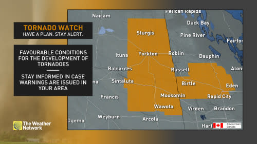
4:22 p.m. CDT – Tornado watches are now in effect across southeastern Saskatchewan and central Manitoba amid a severe storm threat Sunday afternoon. A tornado watch means that conditions are favourable for the development of tornadoes.
Pay close attention to the latest alerts in case the tornado watch is upgraded to a tornado warning in your area. Have a plan in place to seek safe shelter in case severe weather threatens your home, your office, or while you’re driving.
The original article with the full forecast for the Prairies continues below.
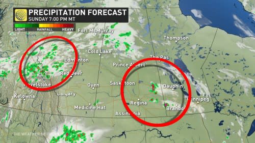
Sunday could be quite a storm-filled day on the Prairies with pockets of severe weather potential in all three provinces.
With an upper-level trough stationed in Saskatchewan, it is helping to provide a lift for thunderstorm development on the Prairies. Pockets of severe storm potential will be peppered across all three provinces, and within some of those risk areas will be a tornado chance.
SEE ALSO: Jasper residents return to wildfire-ravaged townsite as re-entry begins
Saturday saw tornado warnings pop up in parts of Saskatchewan, so it’s important to pay close attention to the latest alerts in case watches or warnings are issued in your area. Have a plan in place to seek safe shelter in case severe weather threatens your home, your office, or while you’re driving.
Prairies see storm and tornado risk surface Sunday
After an active day across Saskatchewan Saturday, another round of severe weather is on tap for Sunday and will shift farther to the east.
Forecasters will be monitoring three pockets of severe storm potential, in particular on Sunday.
One of them will be near the foothills in Alberta in the late afternoon and early evening, as a trough pushing in will give the environment a supportive boost of supercell development. Because of that, the chance of a tornado is on the table.
The other threats with severe storms in Alberta include large hail (golf ball-sized or greater), strong winds, and heavy downpours.
In Saskatchewan and Manitoba, the dynamics are much better for severe storms. The risk of large hail is possible, with sizes ranging from quarter to golf ball in the mix.
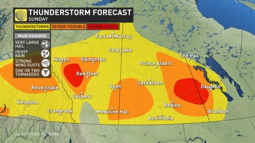
Additionally, the environment is much more potent to support supercells, so the risk of tornado or two is not out of the question.
There is some uncertainty about the exact timing, and what region will see the greatest opportunity for a tornado.
SEE ALSO: Best practices to keep yourself safe from wildfire smoke

Beyond, we are looking at very warm to hot weather to dominate for most of this week with high temperatures ranging from the mid-20s to the lower 30s. Scattered showers and thunderstorms are expected most days, with a risk for localized strong to severe storms and torrential rain.
However, many areas will miss out on the rainfall, especially across southern areas, so an overall dry week for many locations are anticipated.
Thumbnail courtesy: Getty Images.
Stay with The Weather Network for all the latest on conditions across Alberta and the rest of the Prairies.

Real Madrid climb up to second in LaLiga after seeing off Sevilla

NFL Week 16 winners, losers: Bengals keep pace, Eagles lose late
NFL playoff picture, draft order Week 16: Cowboys, 49ers both eliminated from postseason race

49ers eliminated from NFL playoff contention with Commanders’ win
Bryce Young leads Panthers to OT win over Kyler Murray, knocks Cardinals out of playoff race
Bryce Young leads Panthers to win over Kyler Murray, knocks Cardinals out of playoff race
Jayden Daniels, Commanders overcome 5 turnovers to rally past Eagles after Jalen Hurts exits with concussion
NFL Winners and Losers: Bears embarrass themselves again; who will coach this mess in 2025?
Michael Penix Jr. leads Atlanta to victory over Giants in first NFL start
